Commercial promotion and advertising
Reportage and documentary
Detailed photogrammetric survey
Documentation and 3D reconstruction
Inspection and supervision of civil works
Expertize inaccessible or hazardous areas
Overview for insurances, engineering and architecture offices
Sports and events
Health checking of forests and farming
Monitoring of the landscape
Thermal inspections
Fly advertising
Panoramic shoots
Aerial video
Photovoltaic installation maintenance
Electric Power lines maintenance
Overview in case of polluted areas
Historical works census
Turistic promotion
Search and rescue missions
Search of infiltrations
Orthophoto creation
... and much more!
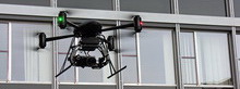
Aerial imaging has made a big rush in a short amount of time. Previously all of the aerial photography was taken using cranes, dollys, airplanes, helicopters or improvised solutions. The actual systems with stabilized mount accomplishes those activities combining the advantages of a crane (stability) and of an helicopter (flexibility) in this new exciting technique.

The maneuverability of our systems allows to fly very close and safely to every object in order to have a detailed and clear vision. The possibilities are endless and thanks to the great flexibility of the system it is always disposable in almost every situation.
Inspections of potential risky objects like big real estate projects, bridges, wind turbines, pipes and aerial power lines becomes easy to do.

With the limited size and the great flexibility it is possible to make photos and videos in any type of terrain and for all kind of investigations. The system can contribute to the research with unique pictures and video for better and faster results.
Razor-sharp and stable images can be realised in case of accident reconstruction or in support of Law enforcement or Emergency services.

Aerial security offers many interesting benefits. With this system it will be easy to provide evidences in emergency situations. Think that the video signal can be broadcasted ensuring to the chain of command to be able to react immediately to any dangerous situation, documenting and assisting the people involved during the interventions.

Being able to observe from a high perspective, in less then 5 minutes we are ready to fly and realize fantastic photo and video to be used for mapping specific areas, for creating georeferenced orthophoto and 3d models without the high cost of the traditional services.

Thanks to the modern thermal camera we are using, it becomes very easy to inspect any object (even the complete roof of a building with a single flight) or a land in order to identify energy wastages or problematic zones that needs to be further analized.